The Mountain Legacy Project
The Mountain Legacy Project: Exploring change in the mountains of western Canada through historical rephotography
For 20 years the Mountain Legacy Project (MLP), based in the School of Environmental Studies at the University of Victoria, has been using repeat photography to examine landscape level change in the Canadian mountain west. Using historical mountain images of amazing fidelity, MLP teams seek to determine the location they were taken from, go to the same place, and rephotograph the images as accurately as possible. MLP researchers then align and analyze the historic and modern images and make them available for use by scholars, students, government agencies, NGOs, schools, the public at large – in fact, anyone interested in exploring Canada’s mountain heights.

An example of a glass plate negative. This plate was taken in 1913 by A.O. Wheeler and crew as part of the Inter-Provincial Boundary Survey between Alberta and British Columbia. It was taken on a ridge below Nub Peak and looks over Magog Lake to the Mt. Assiniboine massif. Photo courtesy of Library and Archives Canada / Bibliothèque et Archives (LAC/BAC) Canada and the Mountain Legacy Project.
The world's largest collection
Canada is fortunate indeed to have the world’s largest collection of systematically taken historic mountain images. Most of the ranges in BC, Alberta, and the Yukon have extensive coverage. The earliest photographs date back to 1861 and are from the Canada/USA International Boundary Commission survey along the 49th parallel. But, of the approximately 120,000 images known to exist, the vast majority come from topographic mapping efforts. Although some reside in private collections, most are held at Library and Archives Canada / Bibliothèque et Archives Canada in Gatineau, Quebec, the BC Archives in Victoria, the Whyte Museum in Banff, and the Glenbow Museum in Calgary.
Made-in-Canada technique
How did Canada come to amass this treasure trove? Imagine it’s the latter part of the 1800s. The newly formed country of Canada faces many challenges, not least of which is how to map the extensive mountain landscapes of the Canadian mountain west. Enter Édouard Deville, then Surveyor General of Canada. In 1886 he introduced a mapping method called phototopography to his surveyors. This made-in-Canada technique required a specially designed camera to be packed up to summits or other high points where a series of panoramic images of the area to be mapped would be taken. Altitude measurements at the photo station – along with angles back to other stations, peaks, and/or fixed points – were also recorded.
The images, captured on 6x4 inch glass plates, would be paired with field measurements and used to create topographic maps. In order for this technique to work it was essential that the features to be mapped be seen in at least two images taken from stations some distance apart. This method proved very successful and was used for much of Canadian mapping in mountainous terrain from 1887 until 1958.
The same 1913 A.O. Wheeler plate as in the first image, this time as a positive. Check out http://explore.mountainlegacy.ca/stations/261 for the location and an overlay view of this image repeated in 2010. B&W inset courtesy of LAC/BAC and MLP.
Early ACC heavyweights involved
In 1887, surveyor James McArthur (called “The first Canadian mountaineer” by Chic Scott in his book Pushing the Limits: The Story of Canadian Mountaineering) was one of the first to use phototopography while mapping mountains around Banff. McArthur was one of many surveyors whose names are synonymous with the early days of Canadian mountaineering: Arthur Wheeler (co-founder of The Alpine Club of Canada), Edward Oliver Wheeler (original member of ACC and Surveyor General of India), Octavius Wilkie (original member of the ACC), Morrison Bridgland (first Chief Mountaineer for the ACC), to name a few. Their maps, along with field notes, early survey reports, and thousands of amazingly detailed historic photographic plates, provide both spectacular views and deep insights into the mountains of western Canada.

A 2017 repeat of the 1913 A.O. Wheeler image (above) from the ridge below Nub Peak. Image courtesy of Mary Sanseverino and MLP.
The legacy project begins
Fast forward to 1996 and the beginnings of what would become the Mountain Legacy Project. Dr. Eric Higgs (MLP lead researcher and ACC member, then with the University of Alberta, now at UVic ) and Dr. Jeanine Rhemtulla (then a grad student at U of A, now faculty at the University of British Columbia) were researching mountain landscape change in the Athabasca valley around Jasper. Discovering Morrison Bridgland’s 1915 Jasper Park survey images of the area led them to retake the shots and compare the modern photos with the 1915 ones. They had to determine exactly where Bridgland stood, make their way to the same spot, and, in order to get close to the same resolution afforded by the glass plates, use professional medium format camera equipment to make the modern retakes.
The Mountain Legacy Project grew from these early days with more and more glass plates located and repeated. As of 2017 MLP teams have repeated over 7,000 historic photographs. These image pairs, along with several thousand as yet unrepeated historic photos are published at mountainlegacy.ca. Over the years MLP researchers have developed and improved techniques for shooting the modern retakes, curating and analyzing the image pairs, and publishing the results. MLP image pairs continue to be used by those who wish to understand past landscape patterns, ecological and human legacies, changes in mountain landscapes, and cultural processes over time.
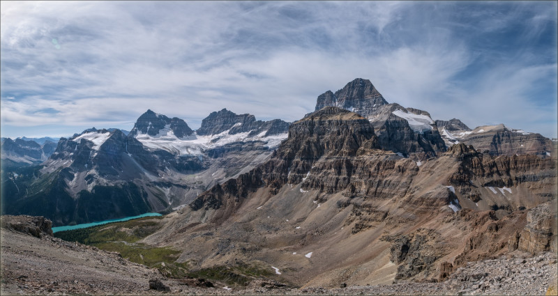
A 2017 panorama taken from The Towers summit showing the eastern side of lofty Mt. Assiniboine, Gloria, Eon, and Aye Peaks (L-R), and the amphitheatre above Gloria Lake. Mt. Terrapin is the broad, triangular summit in the centre right. Panorama courtesy of Mary Sanseverino and MLP.
Explore our mountains through the MLP
The Mountain Legacy Project invites everyone with an interest in mountains to explore and use the collection. All MLP images are available under a Creative Commons license, and can be downloaded, printed, and shared for non-commercial interests. Take a few minutes to climb, hike, and scramble back in time – come exploring with MLP and the mountaineering surveyors of the past who mapped the heights in the Canadian mountain west.
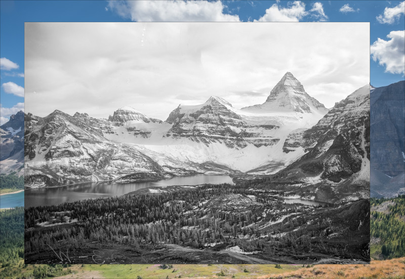
Top image: A split image panoramic overlay featuring two images taken on Sept 14, 1916, by Alan Campbell and Alan (Spike) Thomson, part of A.O. Wheeler’s Inter-Provincial Boundary Survey crew. Check out explore.mountainlegacy.ca for the location and more historic images. B&W images courtesy of LAC/BAC and MLP.
Learn More
- Interact with the Mountain Legacy Project collection (more images regularly added)
- connect with Mountain Legacy on Facebook.
- Learn more about the MLP image analysis toolkit through this Mountain Research and Development paper.
- View more historic/modern panoramic image pairs from Mt. Assiniboine on flickr.