The Last Alder: The Story of the Swan Creek Trail (SCT)
Editor's note: The Alpine Club of Canada maintains 26 backcountry huts – plus another 6 that are maintained by local sections – ranging from family-friendly cabins set in alpine meadows to backcountry powder paradises and remote climbers’ refuges. ACC huts provide basic, rustic shelter for backcountry travellers, offering protection from the elements, and communal cooking and sleeping areas. All of this requires year-round maintenance to keep the wood stocked, the outhouse barrels fresh, and everything in between, including clearing the trail to Fairy Meadow Hut.
Remote trail maintenance poses its own challenges, as described in the story below.
"Alders are vicious and mean.
They ruin trails. They ruin lives!"
– Unknown
This is the story of how a dedicated group of volunteers, over several seasons, fought hard against the dreaded alder and won (for now).
On the doorstep of the Adamant Range sits the famous Bill Putnam or Fairy Meadow Hut. Known for buckets of powder and world-class skiing, the hut sees hundreds of people over the course of a winter and is fully booked throughout the season. The summer season has equal potential for outdoor pursuits as the hut can be used as a base for exceptional climbing and mountaineering objectives. However, it sees far fewer guests in warmer months. This is largely due to the state of the Swan Creek Trail, which slowly degraded over the last 10 years and has begun to look more like a labyrinth than a hut access route.
It’s a jungle out there — one of many large logs on the SCT. Photo: E. Lau.
In the summer of 2016, ACC National Office put a call out looking for volunteers to help clear the Swan Creek Trail. While clearing the roughly nine kilometre long trail to the hut would be no easy task, it was necessary in order to improve access to the area (currently only accessible by helicopter or an unpleasant 10-12 hour hike — i.e. bushwhack – making it expensive and thus unsuitable for most users).
In August, 2016 (August 19-21 to be precise) a small, but mighty group of volunteers met to begin clearing the trail. The first task was finding the trail head situated a mere 63 km down the Kinbasket Lake Logging Road and marking it with a mound of trail blaze. From there we proceeded to hack away at the alders, roots, grasses, and other hair-snatchers which had overgrown the trail. After two days of trail clearing we were certain that we were almost at the hut — but alas we ended the second day with 1.3 km of fresh trail.
A month later eight more volunteers returned to take their turn at reclaiming the SCT. During the weekend of September 23-25 the team worked to clear a large section of trail – 1.6 km on the first day alone! Eclipsing the 1.3 km which were cleared on the two initial maintenance days in August (maybe we weren’t that mighty after all?). By the end of the second day, the team had managed to clear the trail up to the start of the old-growth forest, where the trail was indistinct but not overgrown. The team estimated that 5.4 km were cleared with 3.7 km left for the following summer.
Fast-forward to August, 2017
The ACC Hut Maintenance Team, along with myself and another volunteer, who would prefer to remain anonymous, (for the purpose of this article we’ll call him Eric) set out from the Fairy Meadows Hut to finish the work that had begun last summer. The hut itself is fantastic: a stunning glacial view from the front porch and an ice-cold mountain stream running just behind the hut for cooling beers and bodies. It's the perfect summer oasis! More people need to get up here! And, hopefully, once the trail is complete, they will.

Spectacular views and a natural beer cooler await at the Bill Putnam Hut. Photos: K. O’Rielly.
The top of the trail, which follows a moraine, was clear and easy to navigate. It was only when we approached the old-growth forest area that things started to get alder-y yet again. Several avalanche debris paths made trail navigation difficult so additional trail-markers were added. Felled trees were sawed and branches cleared from the trail.

The top portion of the trail follows along a glacial moraine (which can be spicy in areas so proper boots and a sturdy foot are required); it is clear and distinct. Photo: E. Lau.
Two hot (VERY HOT), mosquito and deer fly-filled days later, we found ourselves connecting to the trail from last year. *release confetti* While Eric and I were able to catch a snazzy ride on a helicopter with the maintenance team into the hut, we had to use our own two feet to get back to the trail head. I forgot to tell Eric this part. But it was sort of neat to be the first people to use the completed trail in its entirety. It was less neat when we lost the trail (almost immediately after the hut maintenance gang had headed back up to the hut) and ended up bushwhacking for a solid 20 minutes.
After shedding a lone tear, we were able to regroup and find the trail once again. It’s only after leaving the “trail” that you realize how much difference even having a partially-kept pathway helps. It’s a jungle out there. While a number of large trees have fallen along the route and an avalanche slide path has taken out a solid 50-metre section of trail, it is possible to get from hut to car with relative ease.

The top portion of the trail follows along a glacial moraine (which can be spicy in areas so proper boots and a sturdy foot are required); it is clear and distinct. Photo: E. Lau.

Photo: E. Lau.

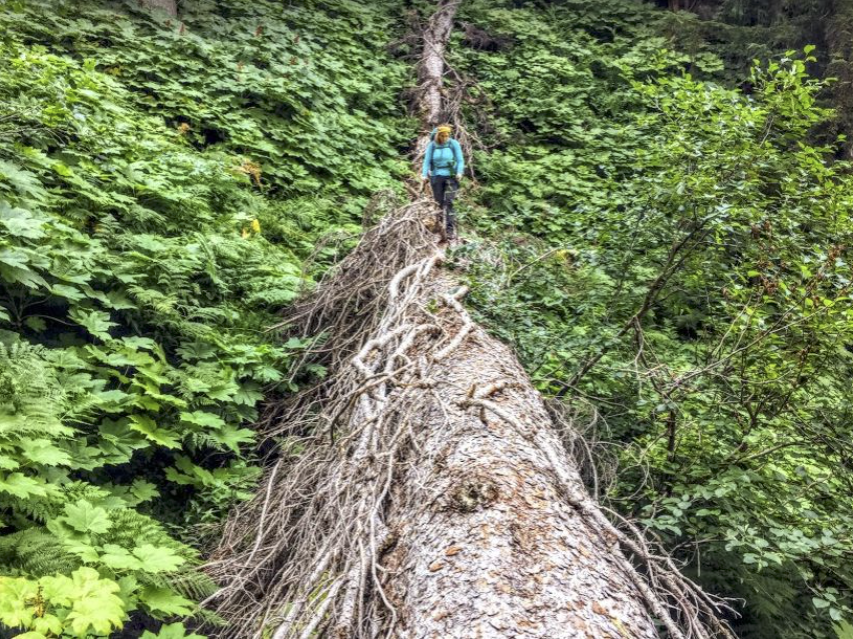
Large trees have fallen across the trail in many places. They would make things treacherous in slippery conditions. These will need to be cut to make the trail easier for users. Photo: E. Lau.

Multi-coloured trail markers exist along the route (see tiny orange – pink? – strand above). The footpath is distinct for largely the entire trail, but greenery has begun to creep back in along the lower half, which was completed in 2016. Photo: E. Lau.

The portion of the trail cleared last summer remains distinct, but alders and other greenery have begun to move back in already. Photo: E. Lau.
A constant battle
Trail building and maintenance is tough work! It takes a community to keep a trail up and running. In the coming seasons, if volunteers don’t head back up to keep things trimmed and pushed back, the trail will likely disappear again. Alders are pesky and they sure know how to grow! While thousands of us use trails to access remote climbing and skiing areas or even just for general hiking enjoyment, very few of us participate in their construction and upkeep. However, with a little effort, a lot of trail maintenance progress can be made by a small number of individuals, even over the course of a couple of weekends. It is still a rough trail so users should come prepared and not expecting world-class hiking terrain. It’s also quite steep, gaining almost 1000m from the trailhead to the hut. Definitely bring a map and GPS. Possibly a radio or other communication device. 63km+ is a long way out and you need to be prepared in case of an emergency.

The Swan Creek Trailhead. It is roughly 50-60 m from where you would park your car. Photo: E. Lau.
Volunteers making our dreams come true
The ACC wouldn’t be the organization that it is today without the support of dedicated volunteers. The trail maintenance weekends were a showcase of the amazing volunteers the club has, that are willing to donate their time and energy to ensure trails are accessible for the entire community to enjoy. The Swan Creek Trail was completed on August 11, 2017, with special thanks to volunteers: Nathan Dahl, Bob Thrasher, Clark Bostrom, Clyde Bostrom, Emily Doyle, Brian Baum, Matt Marshall, Tess Sansom, Gordon Hopper, Kristine O’Rielly and Eric Lau. With special help and organizing from Jeff Stewart and the ACC Hut Maintenance Crew (Nicole, Bill and Sean) and to Steve for providing us with delicious meals at the hut (seafood pasta in the alpine? Yes please!)